We meet the needs of our customers with creativity and comprehensive knowledge.


Technology Field MENU


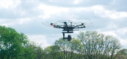
Photogrammetry by using aerial images (UAV)
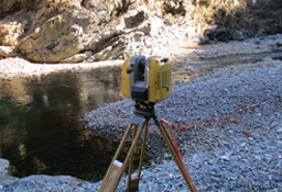
3D survey using laser measurement
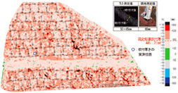
Image of controlled shotcrete thickness by laser measurement instruments

| CLIENT | PROJECT | YEAR |
|---|---|---|
| MLIT Shikoku Regional Development Bureau, Kochi Office of Port and Airport Development | Topographic survey of the coast of Kochi Port | 2016 |
| Kobe Steel, Ltd | Kobe Steel, Ltd, Drawing for approval to meet the soil contamination countermeasures act | 2016 |
| Osaka monorail Co., LTD. | Investigation of present condition, Osaka Chuo Circular Road | 2015 |
| MLIT Kinki Regional Development Bureau, Wakayama Office of Port and Harbor | Surveying of waterway at anchorage, Wakayama-Shimotsu Port | 2015 |
| Aichi Prefectural Government, Shinshiro-Shitara Construction Office | Surveying and design for sabo-work | 2015 |
[Head Office]
4-11-10,Higashinakajima HigashiYodogawa-ku,Osaka,533-0033,JAPAN
TEL:+81-6-6160-1227
FAX:+81-6-6160-1239
[Tokyo Head Office]
2-10-13,Kojimachi,Chiyoda-ku,Tokyo,102-0083,JAPAN
TEL:+81-3-3511-2002
FAX:+81-3-3511-2032
We manage exact measurement of geospatial information
Based on ICT measurement technology (laser measurement, GIS), we perform exact 3D measurement of topography and structures and put the result to 3D design. In addition, we perform 4D measurement adding time and put them to structural maintenance and management under aging. And we also build 3D data based models, thus developing basic data usable for disaster prevention and others.